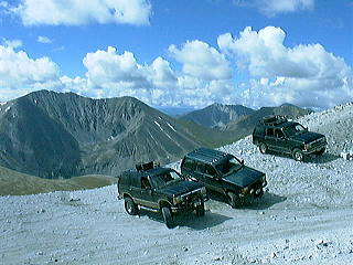
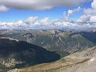
Three Explorers scout the trails during this impromptu
Pre-Run
Friday, August 26
10:50 P.M.: Monday I received an e-mail from Rick, informing
me that Dave Meisner and Ryan Penner will be exploring the planned routes
for the Fall Colors Run. He recommended that I go along. I immediately
jumped at the opportunity, e-mailed both Dave and Ryan volunteering for
the duty. Since that time, I have been looking forward to the weekend.
Wondering if this will be as much fun as Blanding. Will Dave and Ryan be
enjoyable company? Presently they are only names on a page, tomorrow they
become real people. They cant be all bad, after all we share some common
interests: fourwheeling, outdoors, and they too drive explorers. Preparation
has included reading trail guides and programming GPS waypoints.
St. Elmo
It has been raining since 6:00 P.M. What will we find 150 miles away?
Have the mountains in the Salida area also been getting rain? If the trails
are wet, will I be able to negotiate the rocks, mud, and grades without
the aid of lower gearing and lockers? My chosen mode of transportation
is a 1994 Ford Explorer, although equipped with a mild lift and larger
tires, the truck remains generally stock: 3.27 gears, open differentials,
autolock hubs, electric shift transfer case, and 94,000 miles. The Explorer
has proven to be a capable trail runner. The truck has helped me discover
indian ruins in Blanding, canyon trails of Zion, and the desert beauty
of Southern Utah. Most importantly it has introduced me to people like
Jack Lobdell. Now it will show me the mountains of Colorado, and it will
once again introduce me to new friends.
Saturday, August 27
5:30 A.M.: The truck is packed and ready to go. I am already
fatigued from the lack of sleep, but the adrenaline released from the anticipation
of the days events has me charged. Left home with the usual suspicion that
something has been forgotten, but what?
6:00 A.M.: I am joined by Dave Meisner and his co-pilot Ken (did not
catch the last name). Dave has a tricked out four door. Many of us have
seen the photos and write-up, but they do not do justice for such a fine
rig. After short introductions, we are on our way south to Denver. We are
meeting up with Ryan Penned (proud owner of a Sport with 4 lift and ARAB
rear) at his home, but as fate would have it we missed the street on our
first attempt. Luckily we had the trusty cell phones and were able to call
for a little guidance.
7:00 A.M.: Finally all of the participants are gathered. One last stop
for fuel and snacks, then it is off for Salad. Although we had a two hour
drive, time pasted quickly. Thanks to the CB radios, we were able to continue
our introductions at 75 mph.
We decided to keep the same itinerary that Jack had planned for the
trip. This would give us the best information of what to expect on the
Colors Run. Day 1, the three passes Old Monarch at 11,375 feet, Tomichi
at 11,979 feet, and Hancock at 12,140 feet. Day 2, Mt. Anteroom at 14,
269 feet, and Iron Chest trail (elevation irrelevant! we never saw the
top).
10:00 A.M.: Old Monarch Pass is a beautiful road. This road is only
10 miles and so well graded that four wheel drive is not required. If it
were not for the vistas, you could easily find yourself cruising at 35
to 40 mph. The road was originally created in 1880 and served as stage/wagon
route to supply the silver, gold, and lead mines of the Tomato Valley on
the west side.
3:30 P.M.: You may be asking, If Monarch is so easy and only 10 miles,
why does it take 5 hours? Well, it does not. We scouted out a side trail
called Galena Gulch. This was suppose to be a simple 5 mile trail to help
build confidence in those with little or no four wheeling experience. The
trail is well suited to demonstrate the capabilities of a stock Explorer.
It also offers views of mother natures finest handiwork. One section had
me almost believing I was in one of Washington's rain forests. The trail
ends at a mine, at least we believe it does. There were no posted signs,
but we quickly became aware that the route had not seen vehicles for some
time. The trail narrowed from the roadside growth. Saplings were starting
to grow between the tracks. The final clue, coming after there was no where
left to turn around, was the downfall timber. We spent the next three hours
moving logs from off the route. Three switch backs, and an unknown quantity
of trees, later the trail rejoined itself just above the canyon forest.
This trail served to build a team work and commodore which lasted through
out the trip. After this nothing would be impossible (except Iron Chest).
For those interested in this trail, be sure to turn around at the mine,
unless you like scratches from trees in your paint. I am probably still
dragging some dead branches under my truck.
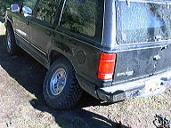
Not nearly as bad as it looks!
The jack sunk in mud while changing a flat.
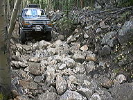
Tomichi Pass was my favorite of the day. Tomichi is the Use Indian word
for hot water. Although there are suppose to be several hot springs in
the area, I was so captivated by the vistas that they went without notice.
Once passing the town of White pine (I was expecting a ghost town, and
found summer cabins complete with phone & power) the trail quickly
takes on the nature as described by Jack. Although the trail is rocky,
the rocks are small. Our only recommendation is that you be sure to have
good light truck tires. This is no place for a passenger type tire, unless
you enjoy changing & fixing flats. Remember to stop at the Tomichi
Cemetery. Although only a few graves are visible, it will remind you what
our ancestors went through to build this Nation. The fall of silver prices
in 1893 closed all but one of the areas mines. It soon fell victim to the
crash, closing in 1895. By 1899, the town of 1500 inhabitants had dwindled
to only six. Tomato townsite was wiped-out by avalanche in 1899, killing
four of the six remaining residents.
The ledge road is near the summit and mostly on the down hill
side. These are wide and stable. As long as you pay attention you will
have no problems. The remains of an earlier rollover at the bottom of the
ledge makes a simple yet effective reminder to go slow and pay attention.
Approaching the summit from the South as we did offered one of the most
breath taking views I can remember.
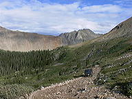
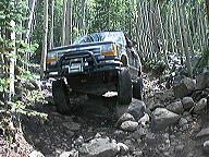
On the trail to Hancock
4:00 P.M. Thanks to our delay at Galena Gulch, we still have Hancock
Pass to negotiate. The trail guide said to allow 1.5 hours and that the
route was harder traveling North. The lower switch backs were somewhat
rough, but nothing that a stock Explorer with a seasoned driver can not
handle. Remember Old Monarch and Tomichi will provide that seasoning, you
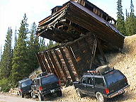
stockers will have no trouble. This trail is highlighted by the much photographed
Allele Belle Mine. It should be quite a sight to see twelve Explorers lined
up, each of the drivers waiting to take a photo under the collapsing structure.
From this point on the road offered easy access, we observed little import
rentals and travel trailers all throughout the are.
6:00 P.M.: We are all getting hungry and decide to find a campsite before
dark. It was decided to camp near Baldwin Lakes along the Mt. Antero Trail.
It turned out to be a rocky slow climb to the area. Shortly before dark
we set camp. The evening included fine dining, stories of trails yet to
be explored, and fabulous pyrotechnics display. With the sun set, the temperatures
began to fall quickly. Firewood in the area was scarce, and that we could
find was damp from the recent rains. Someone, who probably should remain
nameless, decided that an accelerate would be the best method to get the
fire started. Previous attempts with the usual paper, pine needles, and
small twigs had all failed to yield satisfactory results. Pam cooking spray
proved to be marginally effective, but could not generate the heat necessary
to dry the wood. . The final last ditch effort, UNLEADED GASOLINE. Twelve
small ounces was siphoned out of a truck. The logs were soaked. Then with
cigarette lighter in one hand and remaining bottle of gasoline in the other
leaning over the fire pit, Flash! Our friend emerges from a ball of flames
with smoking mustache, eye brows, and hair. Blowing to put out the fumes
emitting from the bottle. Luckily he was not injured.
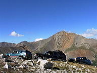
Vista from Mt. Antero, our highest destination.
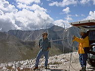
These ham radio operators are speaking to other hams
located on 14,000 ft. peaks across Colorado.
Sunday, August 28
8:00 A.M.: The sun still has not crested the 14000 foot Mt. Antero,
leaving us to endure the cold air. Breakfast is served. The trucks receive
some minor repairs: loose camber bushing and faulty valve stem. The sun
finally crests the mountain, and almost immediately the air begins to warm.
Once again it is a clear blue sky, we could not have asked for a better
day.
The Mt. Antero trail is one of the rockiest, most physically demanding
trails I have taken. This is not metal crushing rock, just nuisance 6
minus stuff with an occasional boulder. A stock truck will be able to negotiate
the trail, as evident by the many we saw throughout the area. We saw pickups
of every size and make, some two wheel drive, Expeditions, Four Runners,
and even a Subaru Forester. Our day started by fording a creek then climbing.
Followed by more climbing. Then the switch backs, where the trail really
goes up. These are nice wide switchbacks. Only a few require a three point
turn. Once again the views are spectacular almost hotizing. You must
keep your concentration here. One careless mistake could be the end of
your truck and everything inside.
Mt. Antero shelf road
We took the opportunity to make a slight detour for photos on a siding.
Ryan lead the way back onto the trail with no problems. I followed, but
because I did not pay particular attention to the line, and got into trouble.
My tire slips, and I am now see-sawing back and forth on two wheels. On
any other trail I would have been nervous, but here I was pucker my ass
petrified. Thanks to Dave and Ken providing counterbalance at the rear
corner, I was able to drive back onto the main trail.
The trail proceeds to a saddle between White Mountain and Mt. Antero.
This saddle should be the break point for those who do not wish to proceed
the final 0.5 miles to the summit. This last section of the trail is narrower,
and the switchbacks were tighter. As an added bonus there are some rocks
to negotiate. I lead point to the summit, reasoning if I could not make
it then we would not try it with stockers. No problem, at least not now
that I was focused on the trail. Once at the summit we found a Cherokee,
Bronco II, Scout, and a couple of Jeeps. I believe a stock Explorer equipped
with good 30 all-terrain tires could make it. Once again the views were
worth the risk.
Plan on spending time at the saddle for lunch, possibly climbing White
Mountain (appeared to be easier), and waiting for a turn to proceed back
down. There are only a few places along the trail where two vehicles can
pass. Depending on traffic you may have to wait for someone climbing to
go by.
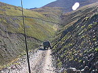
12:00 P.M.: Iron Chest.
I should have known better after rounding the first turn. Perhaps the
CJ at the trail head, with two legs sticking out from under it should have
been my first clue. I was following Ryan with Dave running Cleanup. Ryan
was bouncing, and I mean bouncing, along fairly well. I too was bouncing,
but the thud of rock and metal was coming way to frequent. You know front
differential, spring hanger, shock mount, shackle, cross member.... I knew
I was way beyond my capabilities, but kept going. Perhaps two more inches
of lift, lower gears, lockers front/rear, 4to1 transfer case...I could
have made it. Roughly 200 yards into the trail, my front tire slides off
the line, and crunch, my rocker panel contacts a rock. Luck was with me.
That nifty plastic edge piece was all that contacted. It tore away from
the retainer clips, and hung there flapping. I had enough. I backed up
to a turn around a promptly exited the Iron Chest. Dave and Ryan proceeded
only slightly farther (about twice my distance) before deciding that it
was insane to beat the truck. Although none of us suffered major damage,
the trail did inflict a few scars for reminders. It took 2.5 hours to travel
the approximate length of two city blocks.
Only for the gnarly, Iron chest is one wicked run. This
trail is optional.
Our time was up for trails. We proceeded out of the canyon and into
Buena Vista for supper, then on towards home. Dave and Ryan are great company
on the trail. Although we were only able to squeeze in a sampling of the
trails that are available in the are, there are many other trails which
we be able to conquer come October. The Fall Colors Run next will be exciting
and enjoyable for all. Jack has planned another wonderful trip, I
am sorry that he will not be along for the ride.
The Fall
Colors Run was great!
Check it out!
|